Wednesday, July 31, 2013

Wednesday July 31


We’re in central North Dakota now, we just went through McClusky, ND.  It’s claim to fame is as the geographic center of North Dakota.  This area has many small lakes or ponds.  We’re very surprised by the number of them and that they exist at all.  We crossed Garrison Dam at the end of Lake Sakakawea, the way Sacagawea’s name is spelled and pronounced in the Midwest. We drove through many changes in topography as we headed east, now rolling fields as far as the eye can see. While Montana is known as the Big Sky state. ND could certainly share the title, especially in the eastern part, which is very flat. Working farms quickly replaced the oil fields and prairie as we moved east. We saw wheat, hay, corn, soybeans and fields of beautiful blue flowers (don’t know what they are).  Each town has a grain elevator, the old ones made of wood, the new ones metal, and there are many new ones.  I think ethanol production has stimulated corn production. Many towns are celebrating their centennial, which reminds us how recently the west was developed.   We stopped for coffee at a gas station and chatted with the attendant who had travelled east several times.  He contributed to our decision to travel along the northern shore of Lake Superior into Canada, which he said was a beautiful area.   Yesterday we met a couple from Minnesota at Roosevelt Park who also suggested we take that route.  If two different people suggest something, it has to be done!  We’re spending the night in Hillsboro, ND, just a short distance from the Minnesota border.  By the way, we just learned on the news that it is now legal to carry a gun in church in ND.  We were entertained by the sign for the Bang Church for one reason, this new law provides a whole new interpretation!
 Lewis and Clark Campground, a county campground in Hazen, ND
 Almost like the Overseas Highway in the Keys
 Mom must be driving again!
 Crops waving in the ever-present wind.  It's blowing us east
 Grain (corn?) elevators near Finley, ND
 Centennial celebration
 Big sky, little horizon
 ?

Downtown Portland, ND
Tuesday July 30

We left our oil country dusty field campground just before the rain began, a good thing, because the campground “road” will be a quagmire when wet.  The North Unit of Theodore Roosevelt National Park was more or less on our route, so we stopped in for a few hours.  The park road winds through North Dakota badlands and overlooks the Yellowstone River.  Seeing it in the rain was a contrast to seeing other badlands formations on clear occasions.  It looks much like the badlands in the Southern Unit except more rugged.  The park was developed by the CCC in the 30’s and not much has changed.  Another off the beaten path park.


We picked up Rt 200 again to our camp for the night, Hazen, ND.  This is not oil country, so it was a nice change.  Hazen has two gas stations, two grocery stores, two bars, several businesses, and a school.  That’s about as big as it gets.  We’re camped in the county park, full hookups $20.  We picked this area because there is another Lewis and Clark Interpretive Center, Fort Mandan, and The Knife River Indian Village National Monument.  We of course went to all.  The Interpretive Center has a museum with many artifacts from the period as well as many Indian artifacts.  We didn’t have much time, I wish we could have stayed longer.  At Fort Mandan, where the Corps of Discovery spent the winter, we were fortunate to have an interpreter give us a tour.  The fort is quite nice by frontier standards, with quite a few rooms.  From there we went to the Indian Village.  Here there is a recreation of a Mandan mound house and evidence of where the village stood.  The Mandan were farmers, so returned to the same winter dwellings every year.  The houses are round with a wooden frame, walls, and roof and the whole thing is covered with dirt for insulation.  The interpretive trail to the Knife River goes past the village site and down to the shore where the Indians grew their crops.
 Oil boom traffic
 Drilling a well
 Bison out the truck window up close and personal at TR Park
 Badlands of Theodore Roosevelt NP North Unit

 Looking into the Yellowstone River valley at TR Park


 Fort Mandan, Lewis & Clark Corps of Discovery winter home with Mandan Indians
 Mandan winter lodge

Monday, July 29, 2013

Monday, July 29, 2013

Roadside stop:  Jordan, Montana.  This was the first town we’ve come across that had any services since we left Lewistown 150 miles ago.  Rt. 200 in Montana has many ranches along it but not much in the way of towns.    It was coffee time so we stopped at the café / gas station / general store.  It reminded me a lot of Stewart’s in Pine Plains, not physically, but the same characters were there.  There was no coffee, but there were muffins.  The local Sheriff was at the counter talking to the cashier about local stuff.  After a minute he noticed I was waiting and apologizrd saying “Here I was broadcasting when I should be receiving”, to which the cashier agreed he was good at broadcasting.  I asked if there was coffee next door (through and archway) in the café explaining the machine was empty.  The sheriff was nice enough to go and make another pot for us.  While the coffee was brewing we sat at a table and ate our muffin, getting into a conversation with a local person that had worked at the atomic plant and Boeing in Washington State.  He came back to Montana because there wasn’t any good hunting or fishing near Seattle and the traffic was miserable.  Not a problem around Jordan.  There’s plenty of the first two, none of the third.  Another quote Mom heard was two locals commenting on the weather: “Beautiful day, isn’t it? (reply) Yep, it’s a good fencing day.”  I assume that means cool, sunny, not too windy.  After the coffee was ready, while paying the Sheriff explained he wanted to put a speed limit sign in the store window and related a couple of speeding stories – one about a person that went through town at 60 mph.  There was a person crossing the street, the driver drove behind the person between them and the curb.  His favorite story was stopping a Detroit cop who drove through town at 70 (the speed limit outside of town in Montana.  Two lane, four lane, straight, twisty, hilly, 70 mph.  Let the driver decide how fast to go.)  When the sheriff asked the Detroit cop if he knew why he was stopped, his reply was “What town?”  We got the feeling the Detroit cop did not receive any “Professional courtesy.”

We left Lewistown on the prairie, drove past fields of wheat, which gave way to grasslands and sagebrush with cattle and horses grazing.  This in turn gave way to the hills and gullies of the badlands of North Dakota, then grassland again.  We stopped for lunch in a little town named Richey.  The town grew up before the first world war when the railroad reached this point.  This became the end of the tracks when the US entered WW I and efforts were redirected to the war effort.  The town park offered a pleasant spot to eat.


We’re camped in the middle of the new oil boom – housing is hard to find, RV spaces harder.  This campground keeps two spaces for transients, the rest are oilfield workers.  This once quiet agricultural town now grows housing with constant truck traffic on the highway.  No picnic tables or grills in this campground!  The manager said we picked the campground without the meth heads, but we’re going to lock up well anyway.  Sweet dreams!  Tomorrow we’ll be back in the countryside.
 Jordan is the winner!
 Rt. 200  prairie in eastern Montana
 Jordan Cafe / store / gas station / gossip stop
 This is not a demonstration at some historic park, it's the real thing.  Along Rt 200 in Montana

 Lunch in the Richey town park
 I herd we were entering the grasslands
 Old school vs contemporary income sources - farming and cattle vs oil
 New crop
 Entering North Dakota badlands.  They start at the state line
 Historic approach to housing
 Housing now near Alexander ND in oil country
 Views from our campsite - burning off gasses from gassy wells
 Another section of the "campground".  That's the campground road in the foreground

Sunday, July 28, 2013

Sunday July 28


Out of the mountains and onto the plains was the theme for today.  We dodged a couple of horses and several cows in the road on our way from Glacier but by the time we got to Browning, MT.  the road was clear of animals, anyway.  As usual we found some construction – 6 miles of it.  The way roads are repaired around here is the original road is erased and a gravel and dirt bypass is constructed.  At least this one wasn’t dusty.  We stopped in Great Falls, MT. at Walmart for supplies, then across the Missouri river to the Lewis and Clark Interpretive CenterGreat Falls is named for a series of five waterfalls that the Corps of Discovery had to portage around in 1803 on their way to the Pacific Ocean.  Now five dams harness the power of the river for electricity and the falls are not nearly as impressive as they must have been.  The interpretive center has a movie about the expedition and exhibits related to the exploration.  Remarkably the expedition portaged six dugout canoes and gear18 miles around the falls.  It took a month to complete the portage and construct two more canoes.  Close to the center is the Giant Springs which produces 156 million gallons of water a day and flows into the Missouri.  We walked a path along the river to the spring and back.  Two more hours of prairie and we’re camped in Lewistown, MT. for the night.
 St. Mary, MT. KOA
 Our grizzly bear
 Goodbye, Glacier
 Browning, MT. in Blackfeet country
 Gimmie back my road!
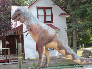
 T Rex in Choteau, MT on Rt. 89
 Great Falls, MT
 Diorama of the portage of canoes around the falls at Great Falls
Great Spring and outflow into the Missouri

Saturday, July 27, 2013

Saturday July 27


Today started at 9:30 with a three mile ranger led hike through meadows and woods and around a beaver pond.  The wildflowers here are more numerous and the most colorful we have seen.  Part of the trail overlooks St. Mary’s lake with the mountains behind making a wonderful scene.  During the walk the ranger mentioned that evening at Many Glacier was a good time to see wildlife, so we filed that tidbit away.  We wanted to go to Many Glacier Lodge and decided that would be a good place for lunch.  It’s about 30 minutes away in another part of the park.  Part of the road runs through Blackfeet territory, and their animals wander around, so on the road to the park there were cattle in the road.  The hotel is magnificent with a Swiss Chalet theme.  The desk clerks wear Lederhosen, etc.  After lunch we sat on the porch overlooking the lake and digested, then back to St. Mary.  We drove part way up the Going to the Sun road on the east, but there is construction, so we turned back.  The plan was to eat and go see some wildlife in the evening as the ranger suggested, so we did.  We were lucky enough to see a large Grizzly bear up on a hillside.  We watched it for fifteen minutes or so as it grazed through bushes, probably eating berries.  It was close enough to see but far away.  No one was going to be eaten.  Now we’ve seen most of the major wildlife here – mountain goat, bighorn sheep, mule deer, white tail deer, and grizzly bear.  We’ve seen elk other places, we’re missing a moose.  Maybe we’ll have to settle for a chocolate mousse somewhere.
 Wildflowers at St. Mary
 Don't eat the bright red ones!
 Indian paintbrush

 View up St. Mary lake toward Many Glacier

 Many Glacier Lodge
 Lobby of Many Glacier Lodge
 Along the road to the Lodge
 Lodge from across the lake
 Many Glacier Lodge
 Amphicar?